Kano State is not just Nigeria’s most populous state but also a centre of commerce, culture, and agriculture. It is undoubtedly one of the powerhouses in Nigeria’s North-West geopolitical zone. Understanding its administrative structure is key for businesses, researchers, and travellers alike.
A common point of confusion we have addressed here on ZIPCODEFOR is the difference between a Local Government Area (LGA) and its headquarters. The LGA is the entire administrative district, much like a county, used in local and regional governments in countries such as Canada, the United Kingdom, the United States, and Ireland. The headquarters of these LGAs in Kano State are usually the main town or city where the local government administration is based.
To help you navigate, here is a complete list of all 44 LGAs in Kano State and their respective headquarters.
The Complete List of Kano State’s 44 LGAs and Headquarters
LGA Name |
Headquarters |
|---|---|
| Ajingi | Ajingi |
| Albasu | Albasu |
| Bagwai | Bagwai |
| Bebeji | Bebeji |
| Bichi | Bichi |
| Bunkure | Bunkure |
| Dala | Dala |
| Dambatta | Dambatta |
| Dawakin Kudu | Dawakin Kudu |
| Dawakin Tofa | Dawakin Tofa |
| Doguwa | Ririwai |
| Fagge | Fagge |
| Gabasawa | Zakirai |
| Garko | Garko |
| Garum Mallam | Garum Mallam |
| Gaya | Gaya |
| Gezawa | Gezawa |
| Gwale | Gwale |
| Gwarzo | Gwarzo |
| Kabo | Kabo |
| Kano Municipal | Kano City |
| Karaye | Karaye |
| Kibiya | Kibiya |
| Kiru | Kiru |
| Kumbotso | Kumbotso |
| Kunchi | Kunchi |
| Kura | Kura |
| Madobi | Madobi |
| Makoda | Makoda |
| Minjibir | Minjibir |
| Nasarawa | Bompai |
| Rano | Rano |
| Rimin Gado | Rimin Gado |
| Rogo | Rogo |
| Shanono | Shanono |
| Sumaila | Sumaila |
| Takai | Takai |
| Tarauni | Tarauni |
| Tofa | Tofa |
| Tsanyawa | Tsanyawa |
| Tudun Wada | Tudun Wada |
| Ungogo | Ungogo |
| Warawa | Warawa |
| Wudil | Wudil |
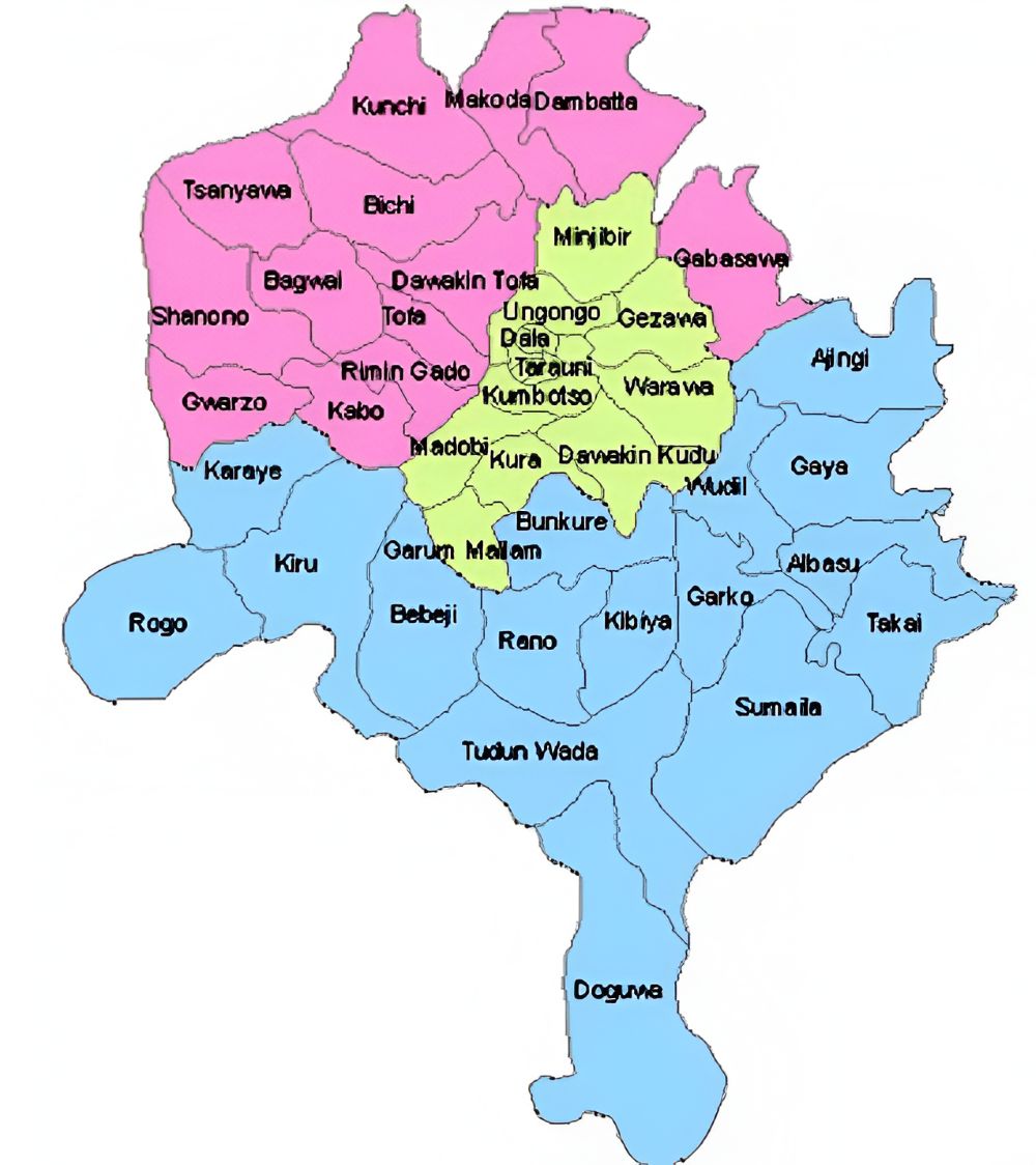
Kano State’s Senatorial Districts
During federal elections and representation in the Senate, Kano State is divided into three Senatorial Districts. Here is how the LGAs are grouped:
1. Kano North Senatorial District
This district covers a wide area in the northern part of the state and includes the following Local Government Areas:
- Bagwai
- Bichi
- Dambatta
- Dawakin Tofa
- Gabasawa
- Gwarzo
- Kabo
- Karaye
- Kunchi
- Makoda
- Rimin Gado
- Shanono
- Tofa
- Tsanyawa
2. Kano Central Senatorial District
This is the metropolitan and central hub of the state, including the state capital:
- Dala
- Dawakin Kudu
- Fagge
- Garum Mallam
- Gezawa
- Gwale
- Kano Municipal
- Kumbotso
- Kura
- Madobi
- Minjibir
- Nasarawa
- Tarauni
- Ungogo
- Warawa
3. Kano South Senatorial District
This district comprises the southern and eastern parts of Kano State:
- Ajingi
- Albasu
- Bebeji
- Bunkure
- Doguwa
- Garko
- Gaya
- Kibiya
- Kiru
- Rano
- Rogo
- Sumaila
- Takai
- Tudun Wada
- Wudil
Why Is This Information Important?
Knowing the correct local government area in Kano and its headquarters is required for:
- Address Verification: Helps ensure all your mail and packages are correctly addressed.
- Business Planning: Understanding the administrative landscape for market analysis and logistics.
- Government Services: Knowing where to go for specific local government services and documentation.
- Travel and Tourism: Serves as a guide to help you navigate and easily plan your trip across the state.
We hope this comprehensive list serves as a valuable resource. For detailed postal code information for any district, street, town, village, or any facility within these LGAs, use our search tool or browse our directory on zipcodefor.com!
